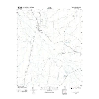
2012 Map of Walnut Grove
USGS Topo · Published 2012About this map
Walnut Grove serves as the central hub of this Mississippi landscape, defined by an intricate network of waterways including Tuscolameta Creek and the meandering Tallabogue. The town's grid of streets, such as Main St and Sylvania St, transitions into a rural topography marked by numerous family and community burial grounds, including True Light Cem, Lindsey Cem, and Britt Cem. This survey illustrates the engineering of the local drainage system, visible in the parallel paths of the North Canal and South Canal that cut across the southern territory near Horseshoe. To the east, the community of Damascus sits near Golden Memorial Park Lake, reflecting the region's blend of outdoor recreation and small-town settlement patterns. The map provides a detailed view of the road networks like Madden Walnut Grove Rd that connected these agrarian communities in the early 21st century.
Find a feature on this map
78 named features on this map. Tap any name to fly to it.
Don’t see what you’re looking for? This feature index may not catch every label — zoom into the map to look around manually.
Map Details
Editions of this 2012 Walnut Grove Map
This is the sole edition of this map. No revisions or reprints were ever made.
Other maps of this area

1921 · Forest
USGS Topo · 1:48,000

1922 · Forest
USGS Topo · 1:62,500

1922 · Morton
USGS Topo · 1:48,000

1924 · Morton
USGS Topo · 1:62,500

1950 · Forest
USGS Topo · 1:62,500

1951 · Morton
USGS Topo · 1:62,500

1952 · Forest
USGS Topo · 1:62,500

1953 · Meridian
USGS Topo · 1:250,000

1957 · Meridian
USGS Topo · 1:250,000

1961 · Carthage
USGS Topo · 1:62,500