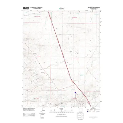
2013 Map of Walsenburg North
USGS Topo · Published 2013About this map
Walsenburg and its northern satellite communities define the landscape of this southern Colorado region, where the high plains meet the foothills of the Sangre de Cristo Mountains. Small settlements such as Pictou, Maitland, and Gordon are concentrated along the winding watercourses of Pictou Arroyo and Maitland Arroyo. The distinctive geological spine of The Hogback rises south of the North Walsenburg Flood Control Reservoir, separating the developed valley from the higher terrain of Walsen Crag.
Find a feature on this map
82 named features on this map. Tap any name to fly to it.
Don’t see what you’re looking for? This feature index may not catch every label — zoom into the map to look around manually.
Map Details
Editions of this 2013 Walsenburg North Map
This is the sole edition of this map. No revisions or reprints were ever made.
Other maps of this area

1891 · Walsenburg
USGS Topo · 1:125,000

1894 · Walsenburg
USGS Topo · 1:125,000

1897 · Walsenburg
USGS Topo · 1:125,000

1900 · Walsenburg
USGS Topo · 1:125,000

1954 · Trinidad
USGS Topo · 1:250,000

1955 · Trinidad
USGS Topo · 1:250,000

1958 · Trinidad
USGS Topo · 1:250,000

1959 · Trinidad
USGS Topo · 1:250,000
1963 · Ritter Arroyo
USGS Topo · 1:24,000
1963 · Walsenburg South
USGS Topo · 1:24,000