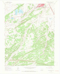
1963 Map of Walsenburg South
USGS Topo · Published 1966About this map
Walsenburg anchors the northern edge of this 1963 survey, appearing as a developed hub during a period of coal mining and early recreation. The landscape is defined by a dense network of industrial sites, including the Watson Robinson Mines, Cameron Mines, and the Globe Mine, alongside the rail corridors of the Denver and Rio Grande Western and the Colorado and Southern. To the west, the emergence of Lathrop State Park around Lake Meriam and Lake Oehm signals the area's transition toward a regional leisure destination.
Find a feature on this map
37 named features on this map. Tap any name to fly to it.
Don’t see what you’re looking for? This feature index may not catch every label — zoom into the map to look around manually.
Map Details
Editions of this 1963 Walsenburg South Map
4 editions found
Other maps of this area

1891 · Walsenburg
USGS Topo · 1:125,000

1891 · Spanish Peaks
USGS Topo · 1:125,000

1893 · Spanish Peaks
USGS Topo · 1:125,000

1894 · Walsenburg
USGS Topo · 1:125,000

1895 · Spanish Peaks
USGS Topo · 1:125,000

1897 · Walsenburg
USGS Topo · 1:125,000

1897 · Spanish Peaks
USGS Topo · 1:125,000

1900 · Spanish Peaks
USGS Topo · 1:125,000

1900 · Walsenburg
USGS Topo · 1:125,000

1954 · Trinidad
USGS Topo · 1:250,000