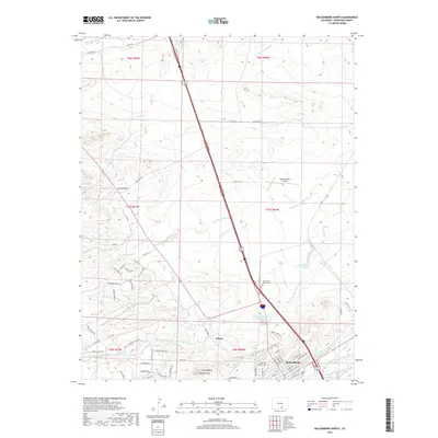
2019 Map of Walsenburg North
USGS Topo · Published 2019About this map
Walsenburg anchors the southern edge of this landscape, where the high plains meet the dramatic geological formations of the Huerfano River valley. The map documents a sophisticated water management network essential to this semi-arid region, featuring the Homestead Canal, Lake Merriam Ditch, and Holita Ditch, alongside several reservoirs such as David E Farr Reservoir. Of significant interest to genealogists and local historians are the Saint Marys North Cem and Huerfano Masonic Cem, which sit near the northern outskirts of the town. North of the city, the settlement of Pictou stands as a distinct community point. The terrain is defined by prominent natural features including The Hogback and the sharp rise of Walsen Crag, while the presence of the Spanish Peaks Airfield indicates the modern infrastructure serving this part of Huerfano County.
Find a feature on this map
79 named features on this map. Tap any name to fly to it.
Don’t see what you’re looking for? This feature index may not catch every label — zoom into the map to look around manually.
Map Details
Editions of this 2019 Walsenburg North Map
This is the sole edition of this map. No revisions or reprints were ever made.
Other maps of this area

1891 · Walsenburg
USGS Topo · 1:125,000

1894 · Walsenburg
USGS Topo · 1:125,000

1897 · Walsenburg
USGS Topo · 1:125,000

1900 · Walsenburg
USGS Topo · 1:125,000

1954 · Trinidad
USGS Topo · 1:250,000

1955 · Trinidad
USGS Topo · 1:250,000

1958 · Trinidad
USGS Topo · 1:250,000

1959 · Trinidad
USGS Topo · 1:250,000
1963 · Ritter Arroyo
USGS Topo · 1:24,000
1963 · Walsenburg South
USGS Topo · 1:24,000