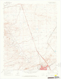
1963 Map of Walsenburg North
USGS Topo · Published 1966About this map
The southern coalfields of Huerfano County come to life in this 1963 survey, revealing an industrial landscape defined by the Denver and Rio Grande Western rail lines and a series of mining settlements. The town of Walsenburg anchors the southeast corner, while smaller company towns and settlements like Maitland, Pictou, and Gordon are shown during a period of transition. The map provides remarkable detail for genealogy and local history, pinpointing numerous active and former industrial sites such as the Morning Glory Mine, Black Beauty Mine, and the Pictou Mine. Infrastructure of the era is clearly visible, from the Walsenburg Landing Field to local landmarks like St Marys Cem and the Gordon Sch. Topographically, the land rises from the Cucharas River valley toward the distinctive ridge of The Hogback, with drainage marked by the Maitland Arroyo and Gordon Arroyo.
Find a feature on this map
42 named features on this map. Tap any name to fly to it.
Don’t see what you’re looking for? This feature index may not catch every label — zoom into the map to look around manually.
Map Details
Editions of this 1963 Walsenburg North Map
This is the sole edition of this map. No revisions or reprints were ever made.
Other maps of this area

1891 · Walsenburg
USGS Topo · 1:125,000

1894 · Walsenburg
USGS Topo · 1:125,000

1897 · Walsenburg
USGS Topo · 1:125,000

1900 · Walsenburg
USGS Topo · 1:125,000

1954 · Trinidad
USGS Topo · 1:250,000

1955 · Trinidad
USGS Topo · 1:250,000

1958 · Trinidad
USGS Topo · 1:250,000

1959 · Trinidad
USGS Topo · 1:250,000
1963 · Ritter Arroyo
USGS Topo · 1:24,000
1963 · Walsenburg South
USGS Topo · 1:24,000