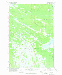
1972 Map of Walsh
USGS Topo · Published 1975About this map
The Seney National Wildlife Refuge dominates this section of the Upper Peninsula, showing a complex hydrological network of marshes and managed waterways in the early 1970s. The landscape is defined by the transition from the Grand Sable State Forest in the north to the extensive wetlands of Creighton Marsh and the Manistique region. The Soo Line railroad cuts a straight east-west path across the center, serving as a distinct boundary between the protected refuge lands and the timber-rich state forest. Water management is evident through features like Pool C-3, Walsh Ditch, and Spur Ditch, which redirect flow between the Walsh Creek and the Driggs River. Local transit is limited to specialized routes like the Ecklund Road and the Creighton Truck Trail, reflecting the area's primary use for conservation and resource management.
Find a feature on this map
20 named features on this map. Tap any name to fly to it.
Don’t see what you’re looking for? This feature index may not catch every label — zoom into the map to look around manually.
Map Details
Editions of this 1972 Walsh Map
This is the sole edition of this map. No revisions or reprints were ever made.
Other maps of this area

1931 · Manistique River NE
USGS Topo · 1:31,680

1931 · Driggs Lake NE
USGS Topo · 1:31,680

1931 · Steuben NE
USGS Topo · 1:31,680

1931 · Manistique River NW
USGS Topo · 1:31,680

1931 · Shingleton NE
USGS Topo · 1:31,680

1931 · Driggs Lake NW
USGS Topo · 1:31,680

1931 · Shingleton SE
USGS Topo · 1:31,680

1931 · Driggs Lake SW
USGS Topo · 1:31,680

1931 · Driggs Lake SE
USGS Topo · 1:31,680

1958 · Shingleton
USGS Topo · 1:62,500