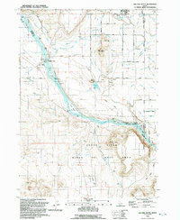
1992 Map of Walters Butte
USGS Topo · Published 1992About this map
The Snake River carves a dramatic path through this high desert landscape, serving as the historical and biological anchor of the region. By the early 1990s, this corridor was defined by its dual identity as a protected habitat and a site of enduring human passage. The Snake River Birds of Prey Natural Area encompasses much of the southern terrain, including the basalt heights of Guffey Butte and Walters Butte. Cultural history is deeply layered here, from ancient Petroglyphs near the riverbanks to the industrial-era Guffey Railroad Bridge. Settlement patterns are concentrated north of the river in Melba and Stoddard, where an intricate network of the Siphon, Aqueduct, and various canals supports agriculture. The historic crossing at Walters Ferry remains a key landmark, while the Celebration County Park marks a shift toward preserving the confluence of archaeological and natural resources.
Find a feature on this map
60 named features on this map. Tap any name to fly to it.
Don’t see what you’re looking for? This feature index may not catch every label — zoom into the map to look around manually.
Map Details
Editions of this 1992 Walters Butte Map
This is the sole edition of this map. No revisions or reprints were ever made.
Other maps of this area

1892 · Bisuka
USGS Topo · 1:125,000

1892 · Silver City
USGS Topo · 1:125,000

1894 · Bisuka
USGS Topo · 1:125,000

1894 · Silver City
USGS Topo · 1:125,000

1898 · Silver City
USGS Topo · 1:125,000

1948 · Sinker Butte
USGS Topo · 1:24,000

1949 · Sinker Butte
USGS Topo · 1:24,000

1949 · Oreana
USGS Topo · 1:62,500

1955 · Boise
USGS Topo · 1:250,000
1957 · Walters Butte
USGS Topo · 1:24,000