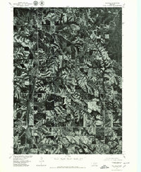
1977 Map of Walthill
USGS Topo · Published 1979About this map
Winnebago and Walthill serve as the primary population centers in this late 1970s orthophotoquad, produced in cooperation with the Bureau of Indian Affairs. The landscape is defined by the sharp contrast between the dense, wooded ravines and the flat, gridded agricultural fields that dominate the uplands. Following the natural contours of the valley, Omaha Creek snakes northward through the western half of the map, accompanied by a prominent transportation corridor that connects the two settlements. This aerial perspective captures the region during a period of established land use, where the intricate patterns of erosion and timber growth in the coulees meet the structured geometry of Nebraska’s farming economy.
Find a feature on this map
3 named features on this map. Tap any name to fly to it.
Don’t see what you’re looking for? This feature index may not catch every label — zoom into the map to look around manually.
Map Details
Editions of this 1977 Walthill Map
This is the sole edition of this map. No revisions or reprints were ever made.
Other maps of this area

1955 · Sioux City
USGS Topo · 1:250,000

1958 · Sioux City
USGS Topo · 1:250,000

1959 · Sioux City
USGS Topo · 1:250,000

1964 · Homer
USGS Topo · 1:24,000

1964 · Salix
USGS Topo · 1:24,000

1966 · Walthill SW
USGS Topo · 1:24,000

1966 · Walthill
USGS Topo · 1:24,000
1966 · Bancroft
USGS Topo · 1:24,000

1966 · Pender NE
USGS Topo · 1:24,000

1966 · Macy
USGS Topo · 1:24,000