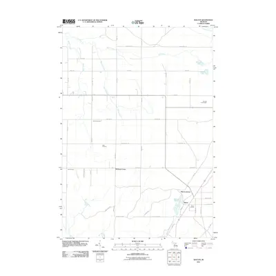
2011 Map of Walton
USGS Topo · Published 2011About this map
Walton Junction serves as the focal point for this landscape in Paradise Township, where the intersection of regional rail lines historically shaped the settlement pattern of southern Grand Traverse County. The community of Walton is situated near the Walton Marsh, where the headwaters of Walton Outlet flow south toward the Manistee River. This geography highlights the importance of drainage and water management in the development of the northern Michigan interior.
Find a feature on this map
49 named features on this map. Tap any name to fly to it.
Don’t see what you’re looking for? This feature index may not catch every label — zoom into the map to look around manually.
Map Details
Editions of this 2011 Walton Map
This is the sole edition of this map. No revisions or reprints were ever made.
Other maps of this area

1954 · Traverse City
USGS Topo · 1:250,000

1956 · Fife Lake
USGS Topo · 1:62,500

1956 · Kingsley
USGS Topo · 1:62,500

1956 · Mesick
USGS Topo · 1:62,500

1956 · Cadillac North
USGS Topo · 1:62,500

1958 · Traverse City
USGS Topo · 1:250,000

1983 · Cadillac
USGS Topo · 1:100,000

1983 · Manton
USGS Topo · 1:25,000

1983 · Traverse City
USGS Topo · 1:100,000
1983 · Kingsley
USGS Topo · 1:25,000
Featured Places
- Paradise Township, MI
- Fife Lake Township, MI
- Union Township, MI
- Greenwood Township, MI
- Liberty Township, MI