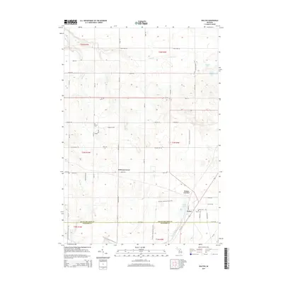
2014 Map of Walton
USGS Topo · Published 2014About this map
Walton and Walton Junction serve as the primary hubs in this landscape, situated near the boundary between Grand Traverse and Wexford Counties. This area reflects a quiet rural character defined by small crossroads and family-named points of interest. Genealogists will find a wealth of burial sites scattered across the township, including the Iliff Grave, Sparling Cem, Milks Cem, Dell Cem, and Walton Cem, which suggest the locations of early homesteads. The topography is marked by significant wetlands like Walton Marsh and the Walton Outlet, while the N Country National Scenic Trail winds through the eastern half of the map. Small water bodies like Parsons Lake and Downs Lake break up the wooded terrain, providing a look at the natural geography surrounding the historic settlement of McManus Corner.
Find a feature on this map
54 named features on this map. Tap any name to fly to it.
Don’t see what you’re looking for? This feature index may not catch every label — zoom into the map to look around manually.
Map Details
Editions of this 2014 Walton Map
This is the sole edition of this map. No revisions or reprints were ever made.
Other maps of this area

1954 · Traverse City
USGS Topo · 1:250,000

1956 · Fife Lake
USGS Topo · 1:62,500

1956 · Kingsley
USGS Topo · 1:62,500

1956 · Mesick
USGS Topo · 1:62,500

1956 · Cadillac North
USGS Topo · 1:62,500

1958 · Traverse City
USGS Topo · 1:250,000

1983 · Cadillac
USGS Topo · 1:100,000

1983 · Manton
USGS Topo · 1:25,000

1983 · Traverse City
USGS Topo · 1:100,000
1983 · Kingsley
USGS Topo · 1:25,000
Featured Places
- Paradise Township, MI
- Fife Lake Township, MI
- Union Township, MI
- Greenwood Township, MI
- Liberty Township, MI