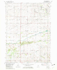
1982 Map of Walton
USGS Topo · Published 1982About this map
Walton and Maytown anchor this 1980s landscape in Lee County, where the agricultural grid meets industrial expansion and conservation. The path of the Green River and the engineered Main Ditch define the local hydrology, supporting both the Green River State Wildlife Management Area and the Industrial Park to the north. For genealogists and local historians, several landmarks offer points of interest, including Williams Cem, Stevens Cem, and the Union Ch. Transportation and utility infrastructure are prominent, with the Burlington Northern railroad and several landing strips like Rasmussen Landing Strip and Albrecht Landing Strip dotting the terrain. The presence of Camp H C Warner and Camp Joy Bible Camp suggests a tradition of rural retreats and youth camps along the river's course.
Find a feature on this map
43 named features on this map. Tap any name to fly to it.
Don’t see what you’re looking for? This feature index may not catch every label — zoom into the map to look around manually.
Map Details
Editions of this 1982 Walton Map
This is the sole edition of this map. No revisions or reprints were ever made.
Other maps of this area

1918 · Dixon
USGS Topo · 1:62,500

1930 · Woodsung
USGS Topo · 1:48,000

1946 · Sterling
USGS Topo · 1:62,500

1948 · Sterling
USGS Topo · 1:62,500

1949 · Walnut
USGS Topo · 1:62,500

1950 · Dixon
USGS Topo · 1:62,500

1951 · Amboy
USGS Topo · 1:62,500

1958 · Aurora
USGS Topo · 1:250,000

1961 · Aurora
USGS Topo · 1:250,000

1982 · Harmon
USGS Topo · 1:24,000