
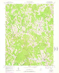
1957 Map of Walton
USGS Topo · Published 1959About this map
The winding Pocatalico River and its dense network of tributaries, such as Ell Fork and Flat Fork, define this mid-century landscape in Roane County. The settlement pattern follows these narrow valley floors, where rural life centered on local institutions like the Walton High Sch and the Big Creek Sch. In the late 1950s, the area's geography was still punctuated by numerous small family-named sites and religious hubs, including Ryan Chapel and Mt Hermon Ch. The presence of several Gas Wells throughout the Harper and Walton districts indicates the significance of resource extraction alongside traditional mountain farming. This survey captures a specific moment when isolated communities like Flint Town, Gandeeville, and Countsville were connected by unimproved dirt roads and telephone lines traversing high points like Huckleberry Knob and Chestnut Point.
Find a feature on this map
66 named features on this map. Tap any name to fly to it.
Don’t see what you’re looking for? This feature index may not catch every label — zoom into the map to look around manually.
Map Details
Editions of this 1957 Walton Map
3 editions found

Other maps of this area

1906 · Kenna
USGS Topo · 1:62,500

1906 · Walton
USGS Topo · 1:62,500

1907 · Kenna
USGS Topo · 1:62,500

1907 · Spencer
USGS Topo · 1:62,500

1907 · Walton
USGS Topo · 1:62,500

1907 · Ripley
USGS Topo · 1:62,500

1926 · Ripley
USGS Topo · 1:62,500

1928 · Spencer
USGS Topo · 1:62,500

1928 · Ripley
USGS Topo · 1:62,500

1954 · Charleston
USGS Topo · 1:250,000