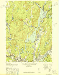
1948 Map of Wanaque
USGS Topo · Published 1948About this map
Wanaque Reservoir dominates the landscape of Passaic County in the years following World War II, its waters contained by the Raymond Dam and Wolf Den Dam. This post-war era shows a region defined by the complex relationship between rising suburbanization and essential water infrastructure. Communities like Midvale, Haskell, and Bloomingdale are well-established along the primary transit corridors, while the northern reaches near Monks and Stonetown remain characterized by rugged terrain and numerous smaller lakes such as Lake Erskine and Lake Iosco. The rail network of the Erie and the New York Susquehanna and Western railroads provide the backbone for local commerce and commuting, intersecting at Pompton Junction. Cultural landmarks like the Salvation Army Camp and the Aquehonga Sch offer a look into the mid-century social fabric of the Highlands.
Find a feature on this map
71 named features on this map. Tap any name to fly to it.
Don’t see what you’re looking for? This feature index may not catch every label — zoom into the map to look around manually.
Map Details
Editions of this 1948 Wanaque Map
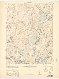
2 editions found
Other maps of this area

1888 · Morristown
USGS Topo · 1:62,500

1888 · Paterson
USGS Topo · 1:62,500

1891 · Greenwood Lake
USGS Topo · 1:62,500

1891 · Ramapo
USGS Topo · 1:62,500

1892 · Paterson
USGS Topo · 1:62,500

1893 · Greenwood Lake
USGS Topo · 1:62,500

1893 · Ramapo
USGS Topo · 1:62,500

1894 · Morristown
USGS Topo · 1:62,500

1898 · Morristown
USGS Topo · 1:62,500

1898 · Paterson
USGS Topo · 1:62,500