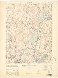
1948 Map of Wanaque
USGS Topo · Published 1950About this map
The Wanaque Reservoir dominates the landscape of northern Passaic County, its extensive shoreline controlled by the Raymond Dam and Wolf Den Dam. This post-war era survey shows the intricate water management system of the Wanaque River valley, where dozens of smaller bodies like Lake Iosco, Lake Erskine, and Harrison Mt Lake are ringed by burgeoning mid-century residential developments.
Find a feature on this map
74 named features on this map. Tap any name to fly to it.
Don’t see what you’re looking for? This feature index may not catch every label — zoom into the map to look around manually.
Map Details
Editions of this 1948 Wanaque Map
2 editions found
Other maps of this area

1888 · Morristown
USGS Topo · 1:62,500

1888 · Paterson
USGS Topo · 1:62,500

1891 · Greenwood Lake
USGS Topo · 1:62,500

1891 · Ramapo
USGS Topo · 1:62,500

1892 · Paterson
USGS Topo · 1:62,500

1893 · Greenwood Lake
USGS Topo · 1:62,500

1893 · Ramapo
USGS Topo · 1:62,500

1894 · Morristown
USGS Topo · 1:62,500

1898 · Morristown
USGS Topo · 1:62,500

1898 · Paterson
USGS Topo · 1:62,500