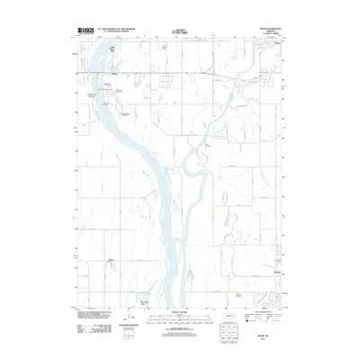
2011 Map of Wann
USGS Topo · Published 2011About this map
The Platte River and Elkhorn River converge in this river-dominated landscape west of Omaha, creating a complex network of channels, sandbars, and floodplain developments. Small communities like Venice and Skyline are situated near these watercourses, while the more substantial settlement of Gretna anchors the southeastern corner. The area is characterized by a significant recreational presence along the riverbanks, evidenced by a dense cluster of sites including Cottonwood Campground, Oak Grove Campground, and Woods Landing Campground and RV Park. Local history is preserved at the Elkhorn Cemetery and Holy Sepulcher Cemetery. Water management is visible through the Diversion Channel and various ponds like Lake Platte View and Big Sandy Lake, reflecting a region shaped by both natural riparian movement and human engineering for agriculture and leisure.
Find a feature on this map
78 named features on this map. Tap any name to fly to it.
Don’t see what you’re looking for? This feature index may not catch every label — zoom into the map to look around manually.
Map Details
Editions of this 2011 Wann Map
This is the sole edition of this map. No revisions or reprints were ever made.
Other maps of this area

1893 · Fremont
USGS Topo · 1:125,000

1896 · Fremont
USGS Topo · 1:125,000

1955 · Fremont
USGS Topo · 1:250,000

1956 · Gretna
USGS Topo · 1:24,000

1956 · Springfield
USGS Topo · 1:24,000

1957 · Fremont
USGS Topo · 1:250,000

1958 · Fremont
USGS Topo · 1:250,000

1968 · Valley
USGS Topo · 1:24,000
1968 · Ashland East
USGS Topo · 1:24,000

1968 · Leshara
USGS Topo · 1:24,000