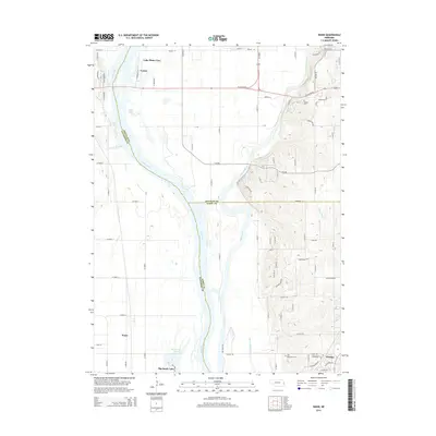
2014 Map of Wann
USGS Topo · Published 2014About this map
Platte River and Elkhorn River dominate the landscape west of Omaha, defining the boundaries where Douglas, Sarpy, and Saunders counties meet. This 2014 survey captures the distinct hydrologic character of the region, from the engineered Diversion Channel and Western Sarpy Ditch to the riverside settlements of Venice and Lake Platte View. The map illustrates a complex network of residential developments and rural expanses, notably around the growing community of Gretna and the smaller locality of Wann. Genealogists and local historians can pinpoint significant landmarks such as Elkhorn Cem and Holy Sepulcher Cem, while also tracing the drainage patterns of S Papillion Cr and Clear Cr. The intersection of major thoroughfares like W Center Rd with established lakes like Trout Lake and Big Sandy Lake highlights the area's transition between agricultural roots and modern suburban expansion.
Find a feature on this map
85 named features on this map. Tap any name to fly to it.
Don’t see what you’re looking for? This feature index may not catch every label — zoom into the map to look around manually.
Map Details
Editions of this 2014 Wann Map
This is the sole edition of this map. No revisions or reprints were ever made.
Other maps of this area

1893 · Fremont
USGS Topo · 1:125,000

1896 · Fremont
USGS Topo · 1:125,000

1955 · Fremont
USGS Topo · 1:250,000

1956 · Gretna
USGS Topo · 1:24,000

1956 · Springfield
USGS Topo · 1:24,000

1957 · Fremont
USGS Topo · 1:250,000

1958 · Fremont
USGS Topo · 1:250,000

1968 · Valley
USGS Topo · 1:24,000
1968 · Ashland East
USGS Topo · 1:24,000

1968 · Leshara
USGS Topo · 1:24,000