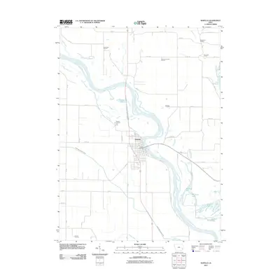
2012 Map of Wapello
USGS Topo · Published 2012About this map
Wapello serves as the central hub of this Louisa County landscape, situated along a prominent bend of the Iowa River. The river's meandering course dominates the eastern half of the map, creating a complex system of backwaters, sloughs, and oxbow lakes including Muskrat Lake, Warnstaff Lake, and the northern reaches of Lake Odessa. The surrounding prairie is defined by a grid of rural roads and drainage projects like the Otter Creek County Ditch, reflecting the area's intensive agricultural character in the early 21st century.
Find a feature on this map
39 named features on this map. Tap any name to fly to it.
Don’t see what you’re looking for? This feature index may not catch every label — zoom into the map to look around manually.
Map Details
Editions of this 2012 Wapello Map
This is the sole edition of this map. No revisions or reprints were ever made.
Other maps of this area

1946 · Wapello
USGS Topo · 1:62,500

1948 · Muscatine
USGS Topo · 1:62,500

1949 · Wapello
USGS Topo · 1:62,500

1953 · Toolesboro
USGS Topo · 1:24,000

1953 · Blanchard Island
USGS Topo · 1:24,000

1958 · Davenport
USGS Topo · 1:250,000

1961 · Davenport
USGS Topo · 1:250,000

1962 · Davenport
USGS Topo · 1:250,000
1965 · Mediapolis
USGS Topo · 1:24,000

1965 · Letts
USGS Topo · 1:24,000