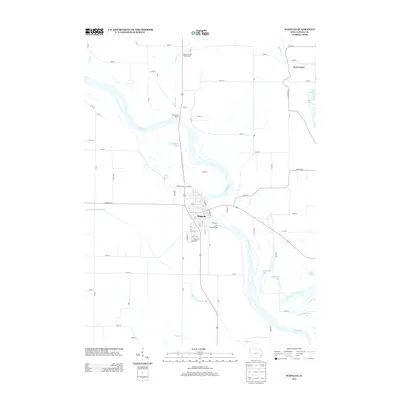
2013 Map of Wapello
USGS Topo · Published 2013About this map
Wapello serves as the focal point of this riverfront landscape, situated where the Iowa River meanders through the fertile bottoms of Louisa County. The town's grid is bounded by historic thoroughfares like State St and Mill St, while the surrounding terrain is defined by a complex network of backwater lakes and sloughs. To the north and south of the main settlement, features like Muskrat Lake, Warnstaff Lake, and Meyerholz Lake illustrate the seasonal pulse of the river valley.
Find a feature on this map
71 named features on this map. Tap any name to fly to it.
Don’t see what you’re looking for? This feature index may not catch every label — zoom into the map to look around manually.
Map Details
Editions of this 2013 Wapello Map
This is the sole edition of this map. No revisions or reprints were ever made.
Other maps of this area

1946 · Wapello
USGS Topo · 1:62,500

1948 · Muscatine
USGS Topo · 1:62,500

1949 · Wapello
USGS Topo · 1:62,500

1953 · Toolesboro
USGS Topo · 1:24,000

1953 · Blanchard Island
USGS Topo · 1:24,000

1958 · Davenport
USGS Topo · 1:250,000

1961 · Davenport
USGS Topo · 1:250,000

1962 · Davenport
USGS Topo · 1:250,000
1965 · Mediapolis
USGS Topo · 1:24,000

1965 · Letts
USGS Topo · 1:24,000