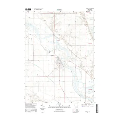
2015 Map of Wapello
USGS Topo · Published 2015About this map
The Iowa River defines the central geography of this Louisa County landscape, winding past the county seat at Wapello. The town’s grid is anchored by thoroughfares like State St and Buchanan Ave, situated on the western bank of the river's wide floodplain. This area is notably dense with burial sites that trace the lineage of local families and institutions, including the Louisa County Farm Cem and the Wilson Farm Cem. To the north, the terrain is shaped by the confluence of Indian Cr and the river, while a complex system of drainage, such as the Otter Creek County Ditch, highlights the region's agricultural management. Numerous oxbow features and small bodies of water like Muskrat Lake and Warnstaff Lake reveal the shifting historical path of the river through the bottomlands.
Find a feature on this map
53 named features on this map. Tap any name to fly to it.
Don’t see what you’re looking for? This feature index may not catch every label — zoom into the map to look around manually.
Map Details
Editions of this 2015 Wapello Map
This is the sole edition of this map. No revisions or reprints were ever made.
Other maps of this area

1946 · Wapello
USGS Topo · 1:62,500

1948 · Muscatine
USGS Topo · 1:62,500

1949 · Wapello
USGS Topo · 1:62,500

1953 · Toolesboro
USGS Topo · 1:24,000

1953 · Blanchard Island
USGS Topo · 1:24,000

1958 · Davenport
USGS Topo · 1:250,000

1961 · Davenport
USGS Topo · 1:250,000

1962 · Davenport
USGS Topo · 1:250,000
1965 · Mediapolis
USGS Topo · 1:24,000

1965 · Letts
USGS Topo · 1:24,000