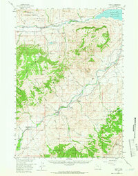
1957 Map of Wapiti
USGS Topo · Published 1966About this map
North Fork Shoshone River and its southern counterpart define the rugged topography of this mid-century Rocky Mountain survey. The landscape is dotted with early-twentieth-century dude ranches and mountain retreats such as Broken H Lodge and the River Rest Resort, reflecting the area's development for outdoor recreation and western tourism. Remote outposts like the Ishawoda Guard Sta and Diamond Bar Cow Camp sit alongside family operations such as the Siggins Brothers Ranch and the Belknap Ranch, highlighting the mix of public land management and private agriculture within the Shoshone National Forest. High-elevation landmarks like Table Mountain and Sheep Mountain overlook a network of irrigation works, including the Valley Ditch and the Lakeview Ditch, which were essential for ranching in the river valleys. The presence of the Hardpan Sch and the Bi Ho Ba Girl Scout Camp points to established community and youth education in this high-country environment.
Find a feature on this map
63 named features on this map. Tap any name to fly to it.
Don’t see what you’re looking for? This feature index may not catch every label — zoom into the map to look around manually.
Map Details
Editions of this 1957 Wapiti Map
2 editions found

Other maps of this area

1893 · Ishawooa
USGS Topo · 1:125,000

1895 · Ishawooa
USGS Topo · 1:125,000

1896 · Crandall Creek
USGS Topo · 1:125,000

1899 · Crandall
USGS Topo · 1:125,000

1899 · Ishawooa
USGS Topo · 1:125,000

1949 · Pat O'Hara Mountain
USGS Topo · 1:62,500

1949 · Cody
USGS Topo · 1:62,500

1951 · Cody
USGS Topo · 1:62,500

1955 · Cody
USGS Topo · 1:250,000

1956 · Dead Indian Peak
USGS Topo · 1:62,500