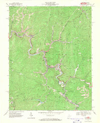
1967 Map of War
USGS Topo · Published 1971About this map
War and the surrounding coal camps of McDowell County appear here in the late 1960s, showing a landscape deeply shaped by mining and rail transport. The Norfolk and Western railway threads through the narrow valleys, serving a string of industrial settlements including Bartley, English, Yukon, and Warriormine. Numerous labels for Mine Dumps, Strip Mines, and a Tipple reflect the intensive resource extraction of the era, while the rugged topography is punctuated by community centers like Mt Airy Ch and the recreation area around Lake Berwind. Further south, the map documents the smaller hamlets of Rift, Berwind, and Canebrake near the State Line Ridge, where the border with Virginia is defined by the high ground of Buchanan County.
Find a feature on this map
44 named features on this map. Tap any name to fly to it.
Don’t see what you’re looking for? This feature index may not catch every label — zoom into the map to look around manually.
Map Details
Editions of this 1967 War Map
2 editions found
Other maps of this area

1891 · Tazewell
USGS Topo · 1:125,000

1895 · Tazewell
USGS Topo · 1:125,000

1897 · Tazewell
USGS Topo · 1:125,000

1910 · Iaeger
USGS Topo · 1:48,000

1912 · Pounding Mill
USGS Topo · 1:62,500

1912 · Iaeger
USGS Topo · 1:62,500

1912 · Welch
USGS Topo · 1:62,500

1914 · Iaeger
USGS Topo · 1:48,000

1915 · Richlands
USGS Topo · 1:48,000

1916 · Pounding Mill
USGS Topo · 1:62,500