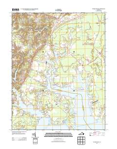
2013 Map of Ware Neck
USGS Topo · Published 2013About this map
North River and Ware River define the intricate, finger-like peninsulas of this Tidewater landscape. The community of Ware Neck sits at the heart of a network of maritime landings and navigational aids, including Auburn Wharf, Hockley Wharf, and the Baileys Wharf Beacon. These features reflect a long-standing reliance on the water for transport and commerce, even as modern routes like the John Clayton Memorial Hwy and Va-14 provide landward access to inland settlements such as Fort Nonsense, Dutton, and Soles. Small aviation fields like Handy Strip Airport and Holly Point Airport dot the terrain, while landmarks such as Cradle Point Light guide vessels through the many creeks and coves, from Blackwater Cr to Parsons Bay.
Find a feature on this map
68 named features on this map. Tap any name to fly to it.
Don’t see what you’re looking for? This feature index may not catch every label — zoom into the map to look around manually.
Map Details
Editions of this 2013 Ware Neck Map
This is the sole edition of this map. No revisions or reprints were ever made.
Other maps of this area

1906 · Williamsburg
USGS Topo · 1:62,500

1916 · Kilmarnock
USGS Topo · 1:48,000

1916 · Mathews
USGS Topo · 1:62,500

1917 · Urbanna
USGS Topo · 1:62,500

1917 · Kilmarnock
USGS Topo · 1:62,500

1917 · Mathews
USGS Topo · 1:62,500

1942 · Kilmarnock
USGS Topo · 1:62,500

1943 · Richmond
USGS Topo · 1:250,000

1948 · Ware Neck
USGS Topo · 1:24,000

1948 · Achilles
USGS Topo · 1:24,000