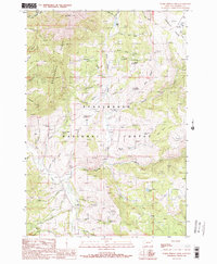
1988 Map of Warm Springs Creek
USGS Topo · Published 1989About this map
Beaverhead National Forest lands dominate this high-elevation mountain terrain where the Greenhorn Range and Gravelly Range converge. The landscape is defined by a complex drainage network feeding into the Ruby River, including Warm Springs Creek and Greenhorn Creek. This 1980s survey captures the region's management as a working forest and rangeland, evidenced by the Warm Springs Cow Camp and a dedicated Holding Pasture. Small-scale resource extraction and water management are visible through several Prospects and the Tate Reservoir in the southern reaches. Numerous named springs such as Schoolmarm Spring, Timber Creek Spring, and Marshall Spring suggest the importance of localized water sources for both livestock and early forest navigation.
Find a feature on this map
54 named features on this map. Tap any name to fly to it.
Don’t see what you’re looking for? This feature index may not catch every label — zoom into the map to look around manually.
Map Details
Editions of this 1988 Warm Springs Creek Map
This is the sole edition of this map. No revisions or reprints were ever made.
Other maps of this area

1888 · Three Forks
USGS Topo · 1:250,000

1893 · Dillon
USGS Topo · 1:250,000

1894 · Three Forks
USGS Topo · 1:250,000

1895 · Three Forks
USGS Topo · 1:250,000

1947 · Bozeman
USGS Topo · 1:250,000

1948 · Bozeman
USGS Topo · 1:250,000

1949 · Varney
USGS Topo · 1:62,500

1950 · Monument Ridge
USGS Topo · 1:62,500

1955 · Bozeman
USGS Topo · 1:250,000

1955 · Dubois
USGS Topo · 1:250,000