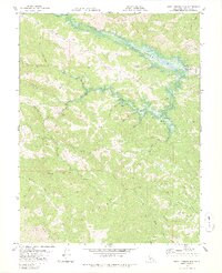
1978 Map of Warm Springs Dam
USGS Topo · Published 1978About this map
Warm Springs Dam (Under Construction) is the defining feature of this 1978 survey, captured as the landscape was being reshaped to form Lake Sonoma. The map illustrates the transition from a network of canyon creeks to a major reservoir, with blue hatching indicating areas destined to be submerged. This change affected historic locations like Skaggs Springs (Hot) and various family-named landmarks such as Pritchett Peaks and Bummer Peak. To the south, the terrain rises toward The Cedars and Walbridge Ridge, where the rugged topography remains less altered by water management. A lone Schoolhouse and scattered Mine and Prospect labels hint at the earlier agricultural and extractive history of this portion of Sonoma County. Travel through these steep hills is marked by the winding Skaggs Springs Road and Rockpile Road, providing a detailed look at the region just before the reservoir reached its full extent.
Find a feature on this map
47 named features on this map. Tap any name to fly to it.
Don’t see what you’re looking for? This feature index may not catch every label — zoom into the map to look around manually.
Map Details
Editions of this 1978 Warm Springs Dam Map
3 editions found

Other maps of this area

1920 · Healdsburg
USGS Topo · 1:62,500

1921 · Skaggs
USGS Topo · 1:62,500

1921 · Kelseyville
USGS Topo · 1:62,500

1933 · Healdsburg
USGS Topo · 1:48,000

1938 · Hopland
USGS Topo · 1:62,500

1940 · Healdsburg
USGS Topo · 1:62,500

1943 · Tombs Creek
USGS Topo · 1:24,000

1943 · Cazadero
USGS Topo · 1:24,000

1943 · Skaggs Springs
USGS Topo · 1:24,000

1943 · Fort Ross
USGS Topo · 1:24,000