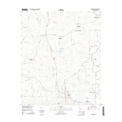
2014 Map of Warm Springs
USGS Topo · Published 2014About this map
Warm Springs serves as the focal point of this 2014 geographic study, reflecting a landscape shaped by historical figures and the natural hydrography of Meriwether County. The legacy of Franklin D. Roosevelt is evident through the presence of the Roosevelt Memorial Airport and the Roosevelt HWY, while the Davis Memorial Lookout Tower stands as a notable landmark to the south. The region is characterized by a network of traditional rural junctions, including Harris City, McLendon Crossroads, and Snelsons Crossroads, illustrating a settlement pattern rooted in early road crossings. Water features like Brae-Tarn Lake, Kendal Cr, and several Cane Cr Structure reservoirs dominate the terrain, underscoring the importance of water management in this part of Georgia. Genealogists will find several family-named burial sites, such as the Judson Bulloch Cem and Ward Cem, which offer physical links to the area's ancestral residents.
Find a feature on this map
108 named features on this map. Tap any name to fly to it.
Don’t see what you’re looking for? This feature index may not catch every label — zoom into the map to look around manually.
Map Details
Editions of this 2014 Warm Springs Map
This is the sole edition of this map. No revisions or reprints were ever made.
Other maps of this area

1907 · Talbotton
USGS Topo · 1:125,000

1934 · Warm Springs
USGS Topo · 1:62,500

1936 · Warm Springs
USGS Topo · 1:62,500

1953 · Atlanta
USGS Topo · 1:250,000

1955 · Phenix City
USGS Topo · 1:250,000

1957 · Phenix City
USGS Topo · 1:250,000

1957 · Atlanta
USGS Topo · 1:250,000

1958 · Phenix City
USGS Topo · 1:250,000

1958 · Atlanta
USGS Topo · 1:250,000
1964 · Pine Mountain
USGS Topo · 1:24,000