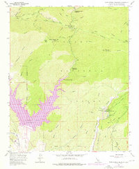
1958 Map of Warm Springs Mountain
USGS Topo · Published 1976About this map
Castaic Lake dominates the lower portion of this mid-century survey, its expansive reach defined by a Spillway Elevation 1515 and situated just north of the Castaic Lagoon. The landscape transitions from the aquatic engineering of the reservoir to the high elevations of Warm Springs Mtn, where the Warm Springs Camp and its associated Swimming Pool provided mountain recreation within the Angeles National Forest.
Find a feature on this map
27 named features on this map. Tap any name to fly to it.
Don’t see what you’re looking for? This feature index may not catch every label — zoom into the map to look around manually.
Map Details
Editions of this 1958 Warm Springs Mountain Map
4 editions found

Other maps of this area

1900 · Fernando
USGS Topo · 1:62,500

1901 · Southern California Sheet No. 1
USGS Topo · 1:250,000

1903 · Tejon
USGS Topo · 1:125,000

1903 · Camulos
USGS Topo · 1:125,000

1903 · Santa Susana
USGS Topo · 1:62,500

1904 · Southern California Sheet No. 1
USGS Topo · 1:250,000

1915 · Elizabeth Lake
USGS Topo · 1:125,000

1917 · Elizabeth Lake
USGS Topo · 1:125,000

1929 · Saugus
USGS Topo · 1:24,000

1931 · Red Mountain
USGS Topo · 1:24,000