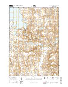
2014 Map of Warm Springs Reservoir
USGS Topo · Published 2014About this map
Riverside sits at the eastern edge of Warm Springs Valley, a vital riparian corridor where the South Fork Malheur River joins the main stem. This 2014 survey captures a landscape defined by water management and high-desert ranching along the Harney County and Malheur County border. To the north, the massive Warm Springs Reservoir dominates the drainage, supported by smaller irrigation features like Riverside Reservoir Number One and Big Curve Reservoir.
Find a feature on this map
32 named features on this map. Tap any name to fly to it.
Don’t see what you’re looking for? This feature index may not catch every label — zoom into the map to look around manually.
Map Details
Editions of this 2014 Warm Springs Reservoir Map
This is the sole edition of this map. No revisions or reprints were ever made.
Other maps of this area

1955 · Burns
USGS Topo · 1:250,000

1958 · Burns
USGS Topo · 1:250,000

1959 · Burns
USGS Topo · 1:250,000

1968 · Venator
USGS Topo · 1:62,500
1972 · Mc Ewen Butte
USGS Topo · 1:24,000
1972 · Stockade Mtn
USGS Topo · 1:62,500
1972 · Hickey Basin
USGS Topo · 1:24,000
1972 · Dunnean
USGS Topo · 1:24,000
1973 · Upton Mountain
USGS Topo · 1:24,000
1973 · Mosquito Mtn
USGS Topo · 1:24,000