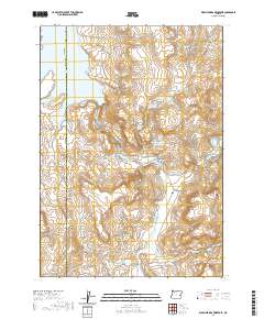
2020 Map of Warm Springs Reservoir
USGS Topo · Published 2020About this map
Riverside sits at a geographic crossroads in eastern Oregon, where the Malheur River meets its southern tributary. This 2020 survey highlights the complex water management system of the high desert, dominated by the Warm Springs Reservoir and smaller irrigation structures like Riverside Reservoir Number One and Riverside Reservoir Number Two. The landscape is a mix of broad basins like Warm Springs Valley and significant volcanic or erosional landforms such as Buck Mtn and Sheep Rock.
Find a feature on this map
31 named features on this map. Tap any name to fly to it.
Don’t see what you’re looking for? This feature index may not catch every label — zoom into the map to look around manually.
Map Details
Editions of this 2020 Warm Springs Reservoir Map
This is the sole edition of this map. No revisions or reprints were ever made.
Other maps of this area

1955 · Burns
USGS Topo · 1:250,000

1958 · Burns
USGS Topo · 1:250,000

1959 · Burns
USGS Topo · 1:250,000

1968 · Venator
USGS Topo · 1:62,500
1972 · Mc Ewen Butte
USGS Topo · 1:24,000
1972 · Stockade Mtn
USGS Topo · 1:62,500
1972 · Hickey Basin
USGS Topo · 1:24,000
1972 · Dunnean
USGS Topo · 1:24,000
1973 · Upton Mountain
USGS Topo · 1:24,000
1973 · Mosquito Mtn
USGS Topo · 1:24,000