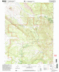
2001 Map of Warner Lake
USGS Topo · Published 2004About this map
The Manti-La Sal National Forest dominates this landscape at the start of the 21st century, revealing a high-altitude wilderness defined by massive landforms and historical conflict. Within the Pinhook Valley, the Pinhook Battleground marks a significant site of the 1881 conflict between settlers and Ute Indians. To the east, the remains of the mining era are preserved at Miners Basin and near Bachelor Basin, tucked into the northern slopes of the La Sal Mountains.
Find a feature on this map
56 named features on this map. Tap any name to fly to it.
Don’t see what you’re looking for? This feature index may not catch every label — zoom into the map to look around manually.
Map Details
Editions of this 2001 Warner Lake Map
This is the sole edition of this map. No revisions or reprints were ever made.
Other maps of this area

1885 · La Sal
USGS Topo · 1:250,000

1954 · Mt. Waas 4 SW
USGS Topo · 1:24,000

1954 · Mt. Waas 4 NW
USGS Topo · 1:24,000

1954 · Mt Peale 1 NW
USGS Topo · 1:24,000

1954 · Mt Peale 2 NW
USGS Topo · 1:24,000

1954 · Mt. Waas 3 NE
USGS Topo · 1:24,000

1954 · Mt. Waas 3 SE
USGS Topo · 1:24,000

1954 · Mt Peale 2 NE
USGS Topo · 1:24,000

1954 · Mt. Waas 3 NW
USGS Topo · 1:24,000

1954 · Mt. Waas 3 SW
USGS Topo · 1:24,000