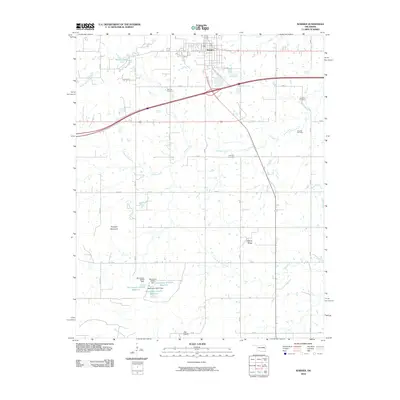
2010 Map of Warner
USGS Topo · Published 2010About this map
The town of Warner serves as the focal point for this Muskogee County landscape, situated where highway corridors intersect with local thoroughfares like College Rd and Lindsay Rd. To the north, Warner Lake and the winding Shady Grove Creek define the hydrology, while the southern reaches transition into more pronounced terrain features such as Dunigan Mountain and Hickory Ridge. The map details a rural infrastructure supported by several reservoirs, including Oknoname 101010 Reservoir and its associated Oknoname 101010 Dam. Genealogists and local historians will find significant value in the distribution of family-named burial sites across the township, from Bennett Cemetery near the central crossroads to the more peripheral Howland Cemetery, Woodall Cemetery, and Foreman Cemetery. These landmarks, along with the broad expanse of Gap Prairie, provide a detailed look at the geographic character of the region in the early 21st century.
Find a feature on this map
32 named features on this map. Tap any name to fly to it.
Don’t see what you’re looking for? This feature index may not catch every label — zoom into the map to look around manually.
Map Details
Editions of this 2010 Warner Map
This is the sole edition of this map. No revisions or reprints were ever made.
Other maps of this area

1900 · Sansbois
USGS Topo · 1:125,000

1901 · Muscogee
USGS Topo · 1:125,000

1905 · Muscogee
USGS Topo · 1:125,000

1909 · Sans Bois
USGS Topo · 1:125,000

1911 · Sansbois
USGS Topo · 1:125,000

1946 · Fort Smith
USGS Topo · 1:250,000

1948 · Keefeton
USGS Topo · 1:62,500

1948 · Webbers Falls
USGS Topo · 1:62,500

1950 · Keefeton
USGS Topo · 1:62,500

1950 · Webbers Falls
USGS Topo · 1:62,500