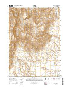
2014 Map of Warner Peak
USGS Topo · Published 2014About this map
Warner Peak and Hart Mtn dominate this high-desert terrain in Lake County, where seasonal water and historic transit routes define the landscape. The inclusion of the Old Military Rd traces a legacy of frontier movement through the region, connecting remote points like Lookout Point and Robinson Draw. Water is a critical resource in this environment, evidenced by the cluster of natural features such as Hot Spring, Indian Springs, and the intermittent waters of Spanish Lake and Thunderbird Lake.
Find a feature on this map
35 named features on this map. Tap any name to fly to it.
Don’t see what you’re looking for? This feature index may not catch every label — zoom into the map to look around manually.
Map Details
Editions of this 2014 Warner Peak Map
This is the sole edition of this map. No revisions or reprints were ever made.
Other maps of this area

1955 · Adel
USGS Topo · 1:250,000

1957 · Adel
USGS Topo · 1:250,000

1958 · Adel
USGS Topo · 1:250,000

1962 · Adel
USGS Topo · 1:250,000

1967 · Flagstaff Lake
USGS Topo · 1:24,000

1967 · Jacobs Reservoir
USGS Topo · 1:24,000

1967 · Campbell Lake
USGS Topo · 1:24,000

1967 · Flook Lake
USGS Topo · 1:24,000

1967 · Alger Lake
USGS Topo · 1:24,000

1967 · Hart Lake
USGS Topo · 1:24,000