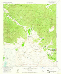
1959 Map of Warner Springs
USGS Topo · Published 1961About this map
Warner Hot Spring and the surrounding Valle de San Jose define this high-desert landscape in northern San Diego County. In the late 1950s, the area served a mix of recreational and military interests, characterized by the presence of the U S Navy Survival Training School and the Warner Springs Landing Field. The map records a transition from traditional ranching properties like Omaya Ranch and Chaney Ranch to modern infrastructure such as the Puerta La Cruz Conservation Camp and the Warner Union School. Water management is central to the local geography, with Lake Henshaw appearing at the southwestern edge, fed by the San Luis Rey River and Agua Caliente Creek. To the north, the terrain climbs toward the Cleveland National Forest and Aguanga Mountain, while smaller features like Deadman Hole and the Sunshine Summit mark the winding route through Dodge Valley.
Find a feature on this map
46 named features on this map. Tap any name to fly to it.
Don’t see what you’re looking for? This feature index may not catch every label — zoom into the map to look around manually.
Map Details
Editions of this 1959 Warner Springs Map
4 editions found
Other maps of this area

1903 · Ramona
USGS Topo · 1:125,000

1904 · Southern California Sheet No. 2
USGS Topo · 1:250,000

1939 · Warner Springs
USGS Topo · 1:62,500

1939 · Santa Ysabel
USGS Topo · 1:62,500

1939 · Palomar Mountain
USGS Topo · 1:62,500

1942 · Ramona
USGS Topo · 1:62,500

1943 · Santa Ysabel
USGS Topo · 1:62,500

1943 · Warner Springs
USGS Topo · 1:62,500

1947 · Ramona
USGS Topo · 1:62,500

1947 · Santa Ana
USGS Topo · 1:250,000