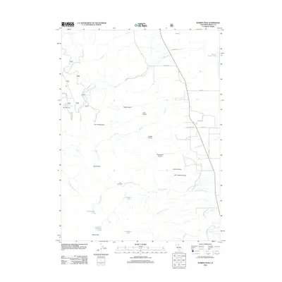
2012 Map of Warren Peak
USGS Topo · Published 2012About this map
Warren Peak rises above a high-altitude landscape of glacial cirques and alpine lakes in the Warner Mountains of Modoc County. The terrain is marked by dramatic vertical relief, from the summit down through Steamboat Canyon and Kaiser Canyon toward the edge of Middle Alkali Lake. High-elevation water bodies like Patterson Lake, Cottonwood Lake, and Lindemann Lake gather near the peaks, feeding the headwaters of numerous drainages including Milk Cr and Cottonwood Cr. Early 21st-century land use is visible through the primitive forest road network, including Co Rd 191 and Laxaque Rd. Evidence of human presence remains sparse and focused on seasonal use, evidenced by the Pepperdine Camp and the remote Tom Smith Cabin situated near Tom Lee Meadows.
Find a feature on this map
43 named features on this map. Tap any name to fly to it.
Don’t see what you’re looking for? This feature index may not catch every label — zoom into the map to look around manually.
Map Details
Editions of this 2012 Warren Peak Map
This is the sole edition of this map. No revisions or reprints were ever made.
Other maps of this area

1886 · Alturas
USGS Topo · 1:250,000

1892 · Alturas
USGS Topo · 1:250,000

1954 · Alturas
USGS Topo · 1:250,000

1958 · Alturas
USGS Topo · 1:250,000

1962 · Alturas
USGS Topo · 1:250,000

1962 · Davis Creek
USGS Topo · 1:62,500

1962 · Cedarville
USGS Topo · 1:62,500

1963 · Warren Peak
USGS Topo · 1:24,000
1963 · Hansen Island
USGS Topo · 1:24,000
1963 · Eagleville
USGS Topo · 1:24,000