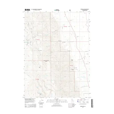
2015 Map of Warren Peak
USGS Topo · Published 2015About this map
Warren Peak and Squaw Peak dominate the high-elevation terrain of this section of the Modoc National Forest. This 2015 survey reveals a complex hydrological network defined by high-altitude basins and steep drainage systems. Glacial or tectonic depressions are home to several alpine water bodies, including Patterson Lake, Cottonwood Lake, and the smaller Lindemann Lake, while Mosquito Lake sits centrally between the peaks. The landscape is carved by numerous canyons, such as Kaiser Canyon and Conklin Canyon, which funnel seasonal snowmelt into creeks like Milk Creek and Cottonwood Creek. Human impact is primarily represented by the forestry road system, including CR-1 and various county routes, and livestock-related sites like Tom Lee Meadows and the Porter Reservoir. The map illustrates the 21st-century management of these protected federal lands, showing the intersection of natural watersheds and infrastructure.
Find a feature on this map
38 named features on this map. Tap any name to fly to it.
Don’t see what you’re looking for? This feature index may not catch every label — zoom into the map to look around manually.
Map Details
Editions of this 2015 Warren Peak Map
This is the sole edition of this map. No revisions or reprints were ever made.
Other maps of this area

1886 · Alturas
USGS Topo · 1:250,000

1892 · Alturas
USGS Topo · 1:250,000

1954 · Alturas
USGS Topo · 1:250,000

1958 · Alturas
USGS Topo · 1:250,000

1962 · Alturas
USGS Topo · 1:250,000

1962 · Davis Creek
USGS Topo · 1:62,500

1962 · Cedarville
USGS Topo · 1:62,500

1963 · Warren Peak
USGS Topo · 1:24,000
1963 · Hansen Island
USGS Topo · 1:24,000
1963 · Eagleville
USGS Topo · 1:24,000