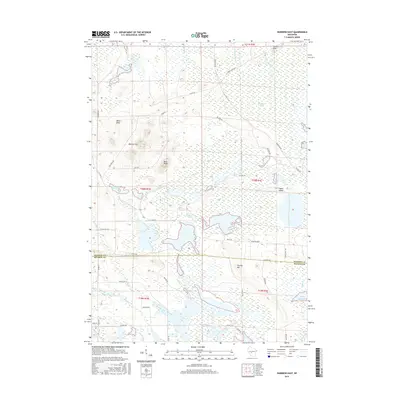
2015 Map of Warrens East
USGS Topo · Published 2015About this map
The E Fork Lemonweir River winds through a landscape of extensive wetlands and cranberry bogs along the border of Jackson and Monroe counties. This area is characterized by complex hydrography, featuring man-made and natural water systems like Goodyear Lake, Scott Flowage, and the drainage networks of Goodyear Ditch and Hunters Peak Ditch. These water features suggest a legacy of regional agriculture and water management essential to the local economy. Rising above the lowlands are distinct geological formations including Winkler Hills, Ball Bluff, and Miles Peak. The transition from the Sawdust Marsh to these higher elevations provided natural landmarks for early travelers and residents. The survey also preserves the names of localized landmarks like Taylor Island and Stanley Hill, offering genealogists and local historians a clear view of the rural spatial organization between Co Hwy HH and Co Hwy EW during the early 21st century.
Find a feature on this map
49 named features on this map. Tap any name to fly to it.
Don’t see what you’re looking for? This feature index may not catch every label — zoom into the map to look around manually.
Map Details
Editions of this 2015 Warrens East Map
This is the sole edition of this map. No revisions or reprints were ever made.
Other maps of this area

1947 · Millston
USGS Topo · 1:62,500

1949 · Millston
USGS Topo · 1:62,500

1953 · Eau Claire
USGS Topo · 1:250,000

1957 · City Point
USGS Topo · 1:48,000

1958 · Eau Claire
USGS Topo · 1:250,000

1958 · Hatfield
USGS Topo · 1:48,000

1958 · Wyeville
USGS Topo · 1:48,000

1964 · Eau Claire
USGS Topo · 1:250,000
1970 · Wyeville
USGS Topo · 1:24,000
1970 · Mather
USGS Topo · 1:24,000