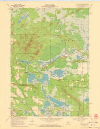
1970 Map of Warrens East
USGS Topo · Published 1972About this map
Warrens and the surrounding marshlands of Lincoln and Scott townships define this 1970 landscape, where the commercial cultivation of cranberries is the dominant agricultural feature. Numerous Cranberry Bogs are carved into the low-lying terrain near the East Fork Lemonweir River and Sawdust Marsh, showing the specialized hydrology of the region. The map captures a moment when industrial extraction and natural preservation coexist, with scattered Sandpits and a Sandpit appearing alongside the expansive State Wildlife Area and Jackson Co Monroe Co Wildlife Area Boundary. Rising above the wetlands are prominent elevations such as Hunters Peak, Miles Peak, and the Winkler Hills. Evidence of earlier settlement and transit persists through Bear Bluff Station, the Morman Cem, and a dedicated Landing Strip situated near Island in the eastern reaches.
Find a feature on this map
33 named features on this map. Tap any name to fly to it.
Don’t see what you’re looking for? This feature index may not catch every label — zoom into the map to look around manually.
Map Details
Editions of this 1970 Warrens East Map
This is the sole edition of this map. No revisions or reprints were ever made.
Other maps of this area

1947 · Millston
USGS Topo · 1:62,500

1949 · Millston
USGS Topo · 1:62,500

1953 · Eau Claire
USGS Topo · 1:250,000

1957 · City Point
USGS Topo · 1:48,000

1958 · Eau Claire
USGS Topo · 1:250,000

1958 · Hatfield
USGS Topo · 1:48,000

1958 · Wyeville
USGS Topo · 1:48,000

1964 · Eau Claire
USGS Topo · 1:250,000
1970 · Wyeville
USGS Topo · 1:24,000
1970 · Mather
USGS Topo · 1:24,000