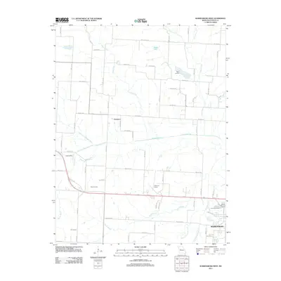
2011 Map of Warrensburg West
USGS Topo · Published 2011About this map
The western outskirts of Warrensburg and the rural community of Greendoor are captured here just before the modern decade, showing a landscape defined by the drainage systems of the Blackwater River. The river's path is fed by the North Fork Blackwater River and South Fork Blackwater River, which converge in a region of significant local genealogy interest. Genealogists will find the locations of Sunset Hill Cemetery, Houx Cemetery, Mount Maria Cemetery, and Dix Cemetery clearly marked among the section lines and farm roads. Aviation history is represented by the Skyhaven Airport and a secondary Landing Strip further west. Water features including Maxson Lake and the winding Post Oak Creek illustrate the natural topography that shaped Johnson County's development, while the extensive network of numbered roads reflects the organized rural grid system that persists today.
Find a feature on this map
64 named features on this map. Tap any name to fly to it.
Don’t see what you’re looking for? This feature index may not catch every label — zoom into the map to look around manually.
Map Details
Editions of this 2011 Warrensburg West Map
This is the sole edition of this map. No revisions or reprints were ever made.
Other maps of this area

1885 · Warrensburg
USGS Topo · 1:125,000

1887 · Warrensburg
USGS Topo · 1:125,000

1894 · Warrensburg
USGS Topo · 1:125,000

1917 · Knobnoster
USGS Topo · 1:62,500

1947 · Jefferson City
USGS Topo · 1:250,000

1954 · Jefferson City
USGS Topo · 1:250,000

1954 · Centerview
USGS Topo · 1:24,000
1954 · Holden
USGS Topo · 1:24,000

1955 · Cornelia
USGS Topo · 1:24,000

1955 · Jefferson City
USGS Topo · 1:250,000