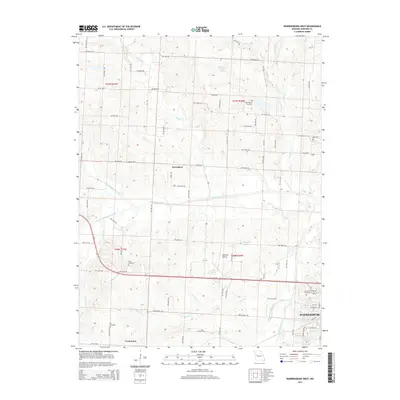
2014 Map of Warrensburg West
USGS Topo · Published 2014About this map
Warrensburg anchors the southeastern corner of this landscape, showing the city's western expansion and residential grid during the early 21st century. The map illustrates a complex drainage system where the N Fork Blackwater River and S Fork Blackwater River converge to form the Blackwater River. This waterway is fed by numerous tributaries including Butcher Br and Devils Br, creating a topography defined by low-lying basins and reservoirs like Maxson Lake and Sky Haven Lake.
Find a feature on this map
82 named features on this map. Tap any name to fly to it.
Don’t see what you’re looking for? This feature index may not catch every label — zoom into the map to look around manually.
Map Details
Editions of this 2014 Warrensburg West Map
This is the sole edition of this map. No revisions or reprints were ever made.
Other maps of this area

1885 · Warrensburg
USGS Topo · 1:125,000

1887 · Warrensburg
USGS Topo · 1:125,000

1894 · Warrensburg
USGS Topo · 1:125,000

1917 · Knobnoster
USGS Topo · 1:62,500

1947 · Jefferson City
USGS Topo · 1:250,000

1954 · Jefferson City
USGS Topo · 1:250,000

1954 · Centerview
USGS Topo · 1:24,000
1954 · Holden
USGS Topo · 1:24,000

1955 · Cornelia
USGS Topo · 1:24,000

1955 · Jefferson City
USGS Topo · 1:250,000