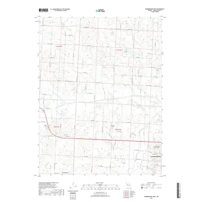
2017 Map of Warrensburg West
USGS Topo · Published 2017About this map
Warrensburg anchor this landscape where the western city limits meet the rural expanse of Johnson County. The area is defined by the convergence of the Blackwater River and its tributaries, including the S Fork Blackwater River and N Fork Blackwater River, which carve drainage patterns across the terrain. Aviation history is prominent here with both Skyhaven Airport and Flecher Field positioned near the primary transit corridors. For genealogists, the map preserves the locations of several community burial sites, including Sunset Hill Cem, Houx Cem, Dix Cem, and Mount Maria Cem. The transition from the established street grid of the city, including W Gay St and W Market St, to the rural township-and-range system illustrates the expansion of this university town into its agricultural surroundings during the late 2010s.
Find a feature on this map
53 named features on this map. Tap any name to fly to it.
Don’t see what you’re looking for? This feature index may not catch every label — zoom into the map to look around manually.
Map Details
Editions of this 2017 Warrensburg West Map
This is the sole edition of this map. No revisions or reprints were ever made.
Other maps of this area

1885 · Warrensburg
USGS Topo · 1:125,000

1887 · Warrensburg
USGS Topo · 1:125,000

1894 · Warrensburg
USGS Topo · 1:125,000

1917 · Knobnoster
USGS Topo · 1:62,500

1947 · Jefferson City
USGS Topo · 1:250,000

1954 · Jefferson City
USGS Topo · 1:250,000

1954 · Centerview
USGS Topo · 1:24,000
1954 · Holden
USGS Topo · 1:24,000

1955 · Cornelia
USGS Topo · 1:24,000

1955 · Jefferson City
USGS Topo · 1:250,000