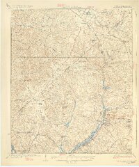
1928 Map of Warrenville
USGS Topo · Published 1928About this map
Horse Creek and its industrial corridor form the heart of this landscape, connecting a series of textile and mill towns including Graniteville, Vaucluse, and Warrenville. Surveyed in the years following World War I, the map captures the transition from the North Augusta area toward the rural highlands of Edgefield and Aiken counties. The density of community institutions is striking, anchored by Bettis Academy and a network of rural schoolhouses like Gardnerville Sch and Jacksonville Sch.
Find a feature on this map
73 named features on this map. Tap any name to fly to it.
Don’t see what you’re looking for? This feature index may not catch every label — zoom into the map to look around manually.
Map Details
Editions of this 1928 Warrenville Map
3 editions found

Other maps of this area

1892 · Mc Cormick
USGS Topo · 1:125,000

1912 · Mc Cormick
USGS Topo · 1:125,000

1920 · Aiken
USGS Topo · 1:48,000

1920 · Talatha
USGS Topo · 1:48,000

1920 · Clarks Hill
USGS Topo · 1:48,000

1921 · Augusta
USGS Topo · 1:62,500

1921 · Aiken
USGS Topo · 1:62,500

1921 · Talatha
USGS Topo · 1:62,500

1921 · Clarks Hill
USGS Topo · 1:62,500

1922 · Hephzibah
USGS Topo · 1:62,500