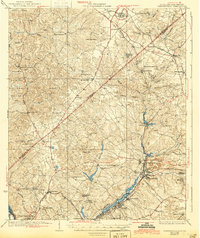
1928 Map of Warrenville
USGS Topo · Published 1944About this map
Horse Creek serves as the industrial spine of this region, connecting a string of mill towns and settlements including Vaucluse, Graniteville, Warrenville, and Langley. These communities, along with the Augusta Aiken Electric Railway (Abandoned), trace the corridor of economic activity between the Edgefield and Aiken county line. To the north, the landscape shifts toward agricultural and timber lands within the Sumter National Forest, characterized by numerous rural churches and schools like Mt Canaan Ch, Science Hill Ch, and the prominent Bettis Academy.
Find a feature on this map
75 named features on this map. Tap any name to fly to it.
Don’t see what you’re looking for? This feature index may not catch every label — zoom into the map to look around manually.
Map Details
Editions of this 1928 Warrenville Map
3 editions found

Other maps of this area

1892 · Mc Cormick
USGS Topo · 1:125,000

1912 · Mc Cormick
USGS Topo · 1:125,000

1920 · Aiken
USGS Topo · 1:48,000

1920 · Talatha
USGS Topo · 1:48,000

1920 · Clarks Hill
USGS Topo · 1:48,000

1921 · Augusta
USGS Topo · 1:62,500

1921 · Aiken
USGS Topo · 1:62,500

1921 · Talatha
USGS Topo · 1:62,500

1921 · Clarks Hill
USGS Topo · 1:62,500

1922 · Hephzibah
USGS Topo · 1:62,500