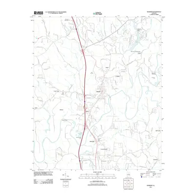
2011 Map of Warrior
USGS Topo · Published 2011About this map
The Locust Fork of the Black Warrior River carves a winding path through this northern Jefferson County landscape, anchoring a network of small settlements and river crossings. The city of Warrior and the town of Kimberly serve as the primary hubs, connected by a corridor of development that includes the communities of Seloca and Linton. Historical family and community ties are preserved in the naming of local landmarks such as Enon Cemetery and Morris Cemetery, while the northern reaches are dominated by the elevation of Thomas Mountain. The hydrology of the area is particularly detailed, showing the convergence of Turkey Creek, Lick Creek, and Cane Creek with the river. Former industrial or river-dependent sites like Coaldale and Beltona appear alongside modern infrastructure, while the McKnally Ford Bridge indicates a long-standing point of transit across the river's rocky channel at Sharit Shoals.
Find a feature on this map
153 named features on this map. Tap any name to fly to it.
Don’t see what you’re looking for? This feature index may not catch every label — zoom into the map to look around manually.
Map Details
Editions of this 2011 Warrior Map
This is the sole edition of this map. No revisions or reprints were ever made.
Other maps of this area

1889 · Birmingham
USGS Topo · 1:125,000

1892 · Birmingham
USGS Topo · 1:125,000

1895 · Birmingham
USGS Topo · 1:125,000

1904 · Birmingham Coal District
USGS Topo · 1:62,500

1905 · Leeds
USGS Topo · 1:62,500

1906 · Birmingham Special
USGS Topo · 1:62,500

1907 · Birmingham
USGS Topo · 1:125,000

1907 · Leeds
USGS Topo · 1:62,500

1951 · Arkadelphia
USGS Topo · 1:24,000

1951 · Warrior
USGS Topo · 1:24,000