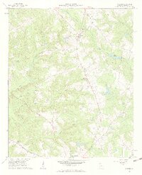
1961 Map of Warthen
USGS Topo · Published 1963About this map
Warthen serves as a central hub in this Washington County landscape, where rural life is defined by a dense network of country churches and watercourses. The 1961 field check captures a community connected by the Sandersville Highway and numerous unpaved paths, reflecting the agrarian character of middle Georgia. A distinct concentration of religious and family landmarks, including Bethlehem Ch, Mt Olive Ch, and Taylor Cem, indicates long-standing settlement patterns.
Find a feature on this map
26 named features on this map. Tap any name to fly to it.
Don’t see what you’re looking for? This feature index may not catch every label — zoom into the map to look around manually.
Map Details
Editions of this 1961 Warthen Map
3 editions found
Other maps of this area

1953 · Athens
USGS Topo · 1:250,000

1957 · Macon
USGS Topo · 1:250,000

1958 · Macon
USGS Topo · 1:250,000

1958 · Athens
USGS Topo · 1:250,000

1959 · Athens
USGS Topo · 1:250,000

1960 · Warthen NE
USGS Topo · 1:24,000

1961 · Deepstep
USGS Topo · 1:24,000

1961 · Warthen
USGS Topo · 1:24,000

1961 · Warthen NW
USGS Topo · 1:24,000

1962 · Tabernacle
USGS Topo · 1:24,000