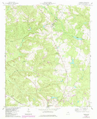
1961 Map of Warthen
USGS Topo · Published 1984About this map
Warthen sits at the intersection of rural transit and agriculture in this Washington County landscape, documented during a period of steady land use in the early 1960s. The settlement's social fabric is clearly visible through a high density of country churches and family burial grounds, including Bethlehem Ch and the Murphy Cem. The terrain is defined by a dendritic drainage pattern of creeks such as Williamson Swamp Creek and Carters Mill Creek, which historically supported local industry as evidenced by Mays Millpond. Industrial activity is also noted at the Claypit south of the main village. This map captures the area just as the Sandersville Highway solidified the connection between these rural communities and the larger county seat to the south.
Find a feature on this map
22 named features on this map. Tap any name to fly to it.
Don’t see what you’re looking for? This feature index may not catch every label — zoom into the map to look around manually.
Map Details
Editions of this 1961 Warthen Map
3 editions found
Other maps of this area

1953 · Athens
USGS Topo · 1:250,000

1957 · Macon
USGS Topo · 1:250,000

1958 · Macon
USGS Topo · 1:250,000

1958 · Athens
USGS Topo · 1:250,000

1959 · Athens
USGS Topo · 1:250,000

1960 · Warthen NE
USGS Topo · 1:24,000

1961 · Deepstep
USGS Topo · 1:24,000

1961 · Warthen
USGS Topo · 1:24,000

1961 · Warthen NW
USGS Topo · 1:24,000

1962 · Tabernacle
USGS Topo · 1:24,000