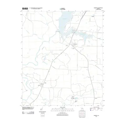
2011 Map of Warwick
USGS Topo · Published 2011About this map
Lake Blackshear dominates the northern landscape of this Worth and Crisp County border region, formed by the Crisp County Dam on the Flint River. The town of Warwick serves as a central hub, surrounded by smaller rural settlements like Oakfield and Marshall. This area is rich in localized history, evidenced by a high density of family and community burial grounds including Smoak Cemetery, New Union Cemetery, and the Fort Early Cemetery. Evidence of earlier industry remains at Davis Mill and the Jordan Company Lake Dam along Jones Creek. The transport network is characterized by numerous country roads and the Saint Regis Landing Strip, reflecting a landscape dedicated to agriculture and water management during the early 21st century.
Find a feature on this map
59 named features on this map. Tap any name to fly to it.
Don’t see what you’re looking for? This feature index may not catch every label — zoom into the map to look around manually.
Map Details
Editions of this 2011 Warwick Map
This is the sole edition of this map. No revisions or reprints were ever made.
Other maps of this area

1953 · Dothan
USGS Topo · 1:250,000

1953 · Waycross
USGS Topo · 1:250,000

1954 · Dothan
USGS Topo · 1:250,000

1955 · Dothan
USGS Topo · 1:250,000

1956 · Sylvester
USGS Topo · 1:62,500

1956 · Albany
USGS Topo · 1:62,500

1956 · Leslie
USGS Topo · 1:62,500

1958 · Waycross
USGS Topo · 1:250,000

1972 · Cuffietown
USGS Topo · 1:24,000
1973 · Albany NE
USGS Topo · 1:24,000