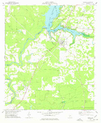
1977 Map of Warwick
USGS Topo · Published 1977About this map
Warwick and Oakfield anchor this Southwest Georgia landscape, where the Flint River is transformed by the massive Lake Blackshear. The map documents the vital infrastructure of the 1970s, from the Crisp County Hydro-electric Plant and its adjacent Powerplant Substation to the Radio Facility Substation. Local history is preserved in the network of country churches such as Bethlehem Ch, Port Early Ch, and New Union Ch, while the agricultural and industrial character is seen in landmarks like Davis Mill and an old Mine near Hanna Branch. The Georgia Northern railroad corridor cuts through the terrain, though sections of the line are marked as abandoned by this era. To the south, the St Regis Landing Strip and a Lookout Tower reflect contemporary land management and transportation needs in a region defined by its water and timber resources.
Find a feature on this map
38 named features on this map. Tap any name to fly to it.
Don’t see what you’re looking for? This feature index may not catch every label — zoom into the map to look around manually.
Map Details
Editions of this 1977 Warwick Map
This is the sole edition of this map. No revisions or reprints were ever made.
Other maps of this area

1953 · Dothan
USGS Topo · 1:250,000

1953 · Waycross
USGS Topo · 1:250,000

1954 · Dothan
USGS Topo · 1:250,000

1955 · Dothan
USGS Topo · 1:250,000

1956 · Sylvester
USGS Topo · 1:62,500

1956 · Albany
USGS Topo · 1:62,500

1956 · Leslie
USGS Topo · 1:62,500

1958 · Waycross
USGS Topo · 1:250,000

1972 · Cuffietown
USGS Topo · 1:24,000
1973 · Albany NE
USGS Topo · 1:24,000