
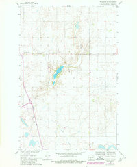
1961 Map of Washburn NE
USGS Topo · Published 1963About this map
Coal Lake and the winding Coal Lake Coulee define this portion of the Missouri River Basin during the early 1960s. This agricultural landscape in McLean County is characterized by scattered rural landmarks and early infrastructure. Local community life centers on sites like the Bible Tabernacle and the Sverdrup Sch in the southern part of the quadrangle. The map reveals the area's geological and economic activity through several marked Mines, Gravel Pits, and the path of Buffalo Creek. A high-elevation Radio Tower stands as a modern fixture amidst the section lines and field boundaries of the North Dakota plains, reflecting a period of development focused on resource management and rural connectivity.
Find a feature on this map
10 named features on this map. Tap any name to fly to it.
Don’t see what you’re looking for? This feature index may not catch every label — zoom into the map to look around manually.
Map Details
Editions of this 1961 Washburn NE Map
2 editions found
Other maps of this area

1929 · Coleharbor
USGS Topo · 1:62,500

1947 · Turtle Lake
USGS Topo · 1:62,500

1949 · Turtle Creek
USGS Topo · 1:62,500

1949 · Washburn
USGS Topo · 1:62,500

1954 · McClusky
USGS Topo · 1:250,000

1958 · McClusky
USGS Topo · 1:250,000

1961 · Turtle Creek SW
USGS Topo · 1:24,000

1961 · Turtle Lake
USGS Topo · 1:24,000

1961 · Lake Nettie
USGS Topo · 1:24,000

1961 · Washburn
USGS Topo · 1:24,000