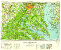
1961 Map of Washington
USGS Topo · Published 1961About this map
The Potomac River serves as the central artery of this mid-century landscape, dividing the urbanizing centers of Washington, Alexandria, and Arlington from the increasingly strategic installations along its banks. The map highlights a massive military presence during the Cold War era, from the U S Naval Academy at Annapolis to the expansive A P Hill Military Reservation and U S Naval Proving Grounds. Transportation patterns reflect a period of transition, featuring the Shirley Highway and the Baltimore & Ohio RR alongside the intricate waterways of the Chesapeake Bay. To the west, the terrain rises toward the Blue Ridge Mts, where landmarks like Little Cobbler Mt stand above rural crossroads. This survey captures a moment when colonial heritage sites, such as the George Washington Birthplace National Monument, existed alongside the sprawling federal footprint of the 1950s and early 60s.
Find a feature on this map
91 named features on this map. Tap any name to fly to it.
Don’t see what you’re looking for? This feature index may not catch every label — zoom into the map to look around manually.
Map Details
Editions of this 1961 Washington Map
2 editions found
Other maps of this area

1884 · Harpers Ferry
USGS Topo · 1:125,000

1887 · Spottsylvania
USGS Topo · 1:125,000

1889 · Fredericksburg
USGS Topo · 1:125,000

1890 · Goochland
USGS Topo · 1:125,000

1890 · Mt. Vernon
USGS Topo · 1:125,000

1891 · Harpers Ferry
USGS Topo · 1:125,000

1891 · Palmyra
USGS Topo · 1:125,000

1891 · Mt. Vernon
USGS Topo · 1:125,000

1892 · Leonardtown
USGS Topo · 1:62,500

1892 · Laurel
USGS Topo · 1:62,500