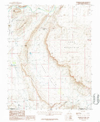
1986 Map of Washington Dome
USGS Topo · Published 1987About this map
Fort Pearce (Site) anchors the southern reaches of this landscape where the Fort Pearce Wash winds through the high desert. This 1980s provisional survey illustrates the geographic transition from the Virgin River and the engineered Washington Canal in the north to the distinctive geological formations that dominate the central terrain. Prominent landmarks such as Shinob Kibe, Washington Dome, and Punchbowl Dome provide clear vertical reference points across a region defined by Warner Ridge and the broad expanse of Warner Valley. The map also details the northeastern edge of Sand Mountain, highlighting a rugged topography of dunes and ridges that shaped early transit and settlement patterns along the Utah-Arizona border. Local industry is briefly noted at the Gravel Pit near the river, while natural water sources like Warner Valley Spring suggest the critical role of water management in this arid environment.
Find a feature on this map
16 named features on this map. Tap any name to fly to it.
Don’t see what you’re looking for? This feature index may not catch every label — zoom into the map to look around manually.
Map Details
Editions of this 1986 Washington Dome Map
This is the sole edition of this map. No revisions or reprints were ever made.
Other maps of this area

1885 · St. George
USGS Topo · 1:250,000

1886 · Mt. Trumbull
USGS Topo · 1:250,000

1891 · St. George
USGS Topo · 1:250,000

1892 · Mt. Trumbull
USGS Topo · 1:250,000

1953 · Cedar City
USGS Topo · 1:250,000

1953 · Grand Canyon
USGS Topo · 1:250,000

1954 · Hurricane Cliffs 2 NW
USGS Topo · 1:24,000

1954 · La Verkin 3 NW
USGS Topo · 1:24,000

1954 · Hurricane Cliffs 2 NE
USGS Topo · 1:24,000

1954 · La Verkin 3 NE
USGS Topo · 1:24,000