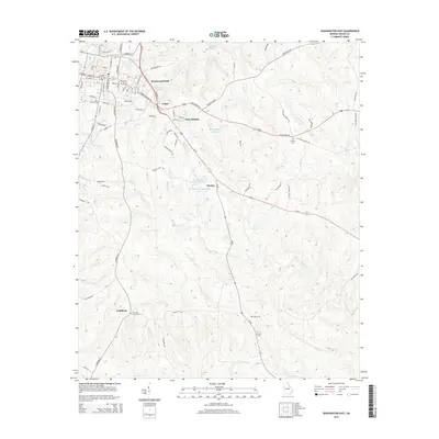
2014 Map of Washington East
USGS Topo · Published 2014About this map
The community of Logan and the surrounding neighborhoods of Ravenwood Park and Anne Heights anchor the residential landscape just east of the historic center of Washington. This survey illustrates a rural-to-suburban transition, where established family-named landmarks like Porters and Lundberg meet the winding drainages of Rocky Cr and Upton Cr. The map is particularly useful for local historians tracking the placement of religious and community sites, such as Smyrna Cem and Mt Zion Cem, which are situated along the secondary road network. The topography is defined by several water bodies, including Booth Lake and Shillinglaw Lake, while the local infrastructure is mapped down to individual residential streets like Lovelace Way and Faver Ave. These details provide a clear view of how the outskirts of the county seat were structured in the early 21st century.
Find a feature on this map
78 named features on this map. Tap any name to fly to it.
Don’t see what you’re looking for? This feature index may not catch every label — zoom into the map to look around manually.
Map Details
Editions of this 2014 Washington East Map
This is the sole edition of this map. No revisions or reprints were ever made.
Other maps of this area

1906 · Crawfordville
USGS Topo · 1:125,000

1953 · Athens
USGS Topo · 1:250,000

1954 · Metasville
USGS Topo · 1:24,000

1955 · Tignall
USGS Topo · 1:24,000

1958 · Athens
USGS Topo · 1:250,000

1959 · Athens
USGS Topo · 1:250,000

1963 · Athens
USGS Topo · 1:250,000
1971 · Celeste
USGS Topo · 1:24,000
1972 · Wrightsboro
USGS Topo · 1:24,000
1972 · Aonia
USGS Topo · 1:24,000